Long-Range 3D Scanners

Long-range LiDAR for buildings, plants, vehicles and whole sites: Ray II for millimeter accuracy from a tripod, Jet for mapping on foot, by vehicle or by drone.

3 produkty
Seřadit podle
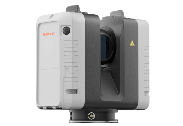
Artec Ray II long-range LiDAR 3D scanner
Artec 3D

Artec Ray II

★★★★★5.0 (2)
59 450 €
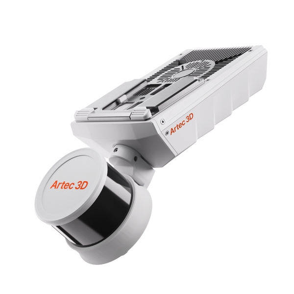
NewArtec Jet SLAM LiDAR mobile mapping scanner
Artec 3D

Artec Jet

38 500 €
Artec Ray II Premium Pack
Artec 3D

Artec Ray II Premium Pack

68 650 €
Choose by job

Precision or coverage: pick your method

Ray II gives maximum accuracy where you set it up. Jet covers whole sites at walking, driving or flying speed.

0.5–130 m

Precision from a tripod

Buildings, plant rooms, aircraft, trucks, bridges and crime scenes
Artec Ray II59 450 €
  • 1.9 mm accuracy at 10 m
  • 360° × 300° view, up to 2 mln points/s
  • Pre-aligned on site, no targets

Also consider Artec Studio Pro — processes Ray II scans and merges Leo close-ups

0.5–300 m

Whole sites on the move

Mines, tunnels, plants, stockpiles and stadiums, on foot, vehicle or drone

Artec Jet38 500 €
  • ±10 mm indoor and underground
  • Up to 1.92 mln points/s, 360° × 290°
  • Works in darkness and without GPS

Also consider Artec Twins — processes, georeferences and merges Jet data with Ray II

Real scan data

Real long-range datasets

A truck, a 12 m piping system and a multi-ton machine scanned from a tripod, plus a concert hall, a castle and a mine mapped on the move.

Semi-trailer truck
Whole vehicle

Semi-trailer truck

Ray II captured the whole truck, Leo the underside and the cab gap, for aerodynamic simulation.

Scanned with
Artec Ray II + Artec Leo
Scan time
6 h
Processing
10 days

Results from long-range projects

5h

Ray II captured ceilings 20–30 m away and ornate carvings up close from 40 positions, at up to 1.9 mm accuracy, replacing months of manual measuring.

Scanned withArtec Ray II

76kW

Ray II captured the whole truck and Leo the cab and underside for a CFD-ready model. CFD results came back in hours and pointed to changes to mirrors and roof.

Scanned withArtec Ray II

30min

Carried on a backpack and mounted on a vehicle, Jet captured the whole stadium in color, scoreboard included from ground level, in a window that fits between games.

Scanned withArtec Jet

How much does a long-range scanner cost?

Artec Ray II is 59 450 € in our store, or 68 650 € as a Premium Pack with a carbon tripod, a travel backpack, a 5-year Artec Studio license and a 2-year warranty instead of one. Artec Jet is 38 500 €, with a 2-year warranty; drones for aerial mapping are sold separately.

On large sites, the two combine well: Jet covers the whole site at walking, driving or flying speed, Ray II adds precision on facades, plant rooms and key structures, and the data merges in Artec Twins. An Artec 3D expert can help you plan the mix in a free demo.

Questions about long-range 3D scanners

Ray II or Jet: which do I need?

Ray II is a tripod-mounted terrestrial scanner for maximum accuracy in focused areas, 1.9 mm at 10 m. Jet is a mobile SLAM mapper for speed and full-site coverage. Their data can be merged in Artec Twins.

How far can they scan?

Ray II measures from 0.5 to 130 m and covers 360° × 300° from each position. Jet measures from 0.5 to 300 m with a 360° × 290° field of view while it moves.

Do I need targets or GPS?

No. Ray II aligns each position on the spot with its visual inertial system, so scans arrive pre-aligned. Jet positions itself by SLAM, works in GPS-denied areas and can use ground control points or RTK for georeferencing.

Do the scans include color?

Ray II captures calibrated 360° imagery with a 36 MP three-camera system and automatic HDR. Jet records intensity by default; true color needs the optional action camera kit, aligned automatically in Artec Twins.

Can they work outdoors and in harsh conditions?

Ray II is rated IP54 and operates from −5 to +40 °C. Jet is rated IP65, operates from −10 to 45 °C and works in complete darkness.

Which software do I need?

Ray II data is processed in Artec Studio, which also merges Leo close-ups. Jet data is processed in Artec Twins, built for multi-billion-point datasets from Jet, Ray II and Leo.

How accurate are the point clouds?

Ray II reaches 1.9 mm at 10 m, 2.9 mm at 20 m and 5.3 mm at 40 m, with 18-arcsecond angular accuracy. Jet maps at ±10 mm indoors and underground and ±15 mm in general environments, with ±5 mm change detection.

Can I combine point clouds from other scanners or drones?

Yes. Artec Twins fuses satellite, drone, smartphone and Artec scanner data into one dataset, and standard files from other devices import too. It handles environments of 100 km² and more.

Planning a site survey?

See long-range LiDAR on sites like yours

Book a live demo with an Artec 3D expert. Bring your questions about range, accuracy, deployment and deliverables.